
читать >> На этом сайте: представлена географическая поэзия - описания путешествий, путевые заметки, впечатления о поездках, отчёты об экспедициях. Для читателей-путешественников. Стихи о городах: стихи о Париже, стихи о Венеции, о Риме. Стихи о странах: стихи об Италии, стихи о Франции, об Америке. География в стихах: стихи о дорогах, о путешествиях. Мир в стихах: стихи о земле, стихи о горах, об Океане etc. Попутно городской клининг. В помощь преподавателям географии, литературы и природоведения. |
|
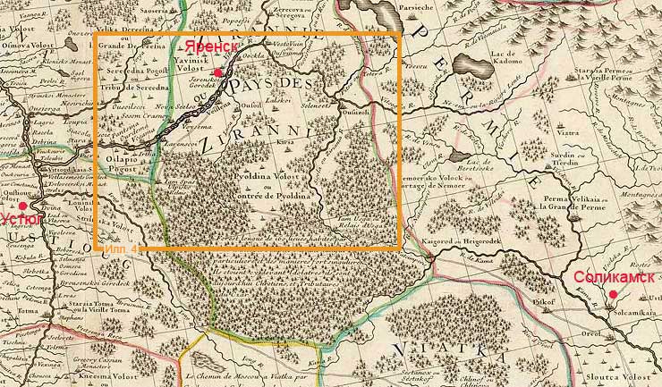
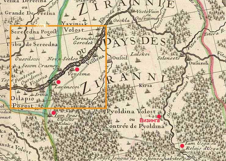
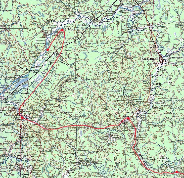
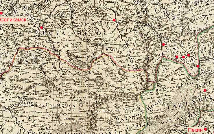
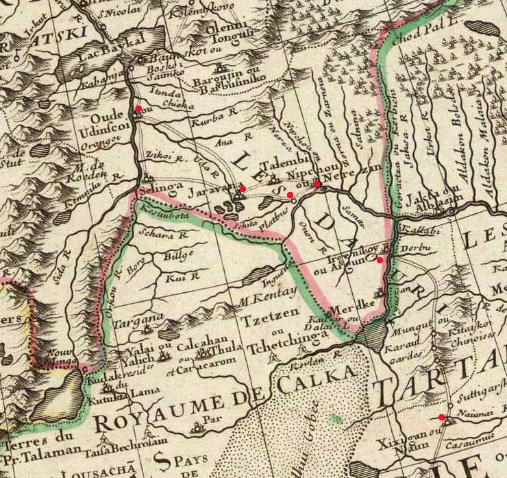
The decoding of the Robinson Crusoe's route through Russia in 1704 by Pavel Mityushev, ABSTRACT In the second part of Daniel Defoe's novel "The Further Adventures of Robinson Crusoe" (1719), Robinson makes a trip from China to Europe via Russia. This story is well-known. But to the moment, the considerable part of the geographical items of his trip had not been identified (or had erroneously). In this work the real Crusoe's rout is determined on the basis of the sources and documents. The method of geographical identification has been proposed. The two main principles of the method are: At first, we verified all toponyms and hydronyms of the Russian part of Crusoe's trip according to the first edition of the novel (W. Taylor, 1719). Because in the later editions, especially after 1801, some distortions in a spelling of a row of toponyms occures. For example, "Veussima" became "Veuslima", "Ozomya" – "Ozomoys" etc. Than, the Defoe's possible cartographical source was determined. The main historical maps of the Russian North were researched: the map by Siegmund Freiherr von Herberstein (1546), by Antonio Jenkinson (1562), by William Borowgh (1570), by Hessel Gerritsz (1613), by Erik Palmquist (1673), the maps and travelogs by Ysbrants Ides and Adam Brand (1698) - and others. As the result it has been shown that the map by Guillaume de l'Isle (Delisle, Carte de Moscovie, 1706) was the Defoe's source (see ill. 1). ill. 1. North-East part of European Russia on the map by Guillaume de l'Isle (1706) The European part of Crusoe's Russian trip was researched first. The toponyms from the Defoe's novel between Solikamsk town and Vychegda river were identified by Delisle's map. The result was the next (see ill. 2): ill. 2. River Vychegda area on the map by Guillaume de l'Isle Further, it has been shown that the only possible way to get Voysema (on Vychegda river) from Solikamsk in 1704 was the Old Siberian Road (now not existed and signed at Delisle's map not very correctly). The real Crusoe's itinerary in terms of the Delisle's map was the next (see ill. 3): ill. 3. Robinson Crusoe's route through Russia (European part) on the map by Guillaume de l'Isle The last our step was the identification of the names from Delisle's map (actually ancient) – not always sufficient evident. Our research showed that: ill. 4. Robinson Crusoe's route through Russia (European part) on the modern topographical map The Siberian part of the Robinson Crusoe's trip was decoded as well (see ill. 5). It has been shown that the mysterious "Plothus" and "Jarawena" (see ill. 6) from the novel (Plathus and Jaravana by Delisle's map) are modern town Chita (Чита, N52.045, E113.456) and village Shiringa (Ширинга, former "Yeravninsky ostrog", N52.230, E112.939) correspondingly. Also, Naun = modern Xixigar (China), Adinskoy = modern Ulan-Ude (Улан-Уде), etc. ill. 5. Robinson Crusoe's route through Russia (Siberian part) on the map by Guillaume de l'Isle
ill. 6. Robinson Crusoe's route through Russia (east part of Siberia) RESUME: May 2010, Moscow |
|
 Едешь в Рим?
Пригодится в дороге
Новое: Парагвай, 3 стр. Мексика, 8 стр. Фото Бразилии, 58 стр. Галерея "Линии", 23 стр. Галерея "Диагонали", 41 стр. Венесуэла, 127 стр. Фото Венесуэлы, 284 стр. Карта Рораймы, 2 стр. Карибское море, 34 стр. Австрия, 6 стр. Гайана, 25 стр. Франция: Луара, Нормандия, Бретань, Лион, Дофинэ, Прованс, Марсель, 146 стр. Япония, 28 стр. Филиппины, 26 стр. |

|